GOES-R Series Resource Reel
- 1920x1080 quicktime (5.8 GB) 29.97 fps ProRes version for Video Editors
- 1280x720 mpeg-4 (510.7 MB) 29.97 fps
- 1280x720 mpeg-4 (90.4 MB) 30.0 fps
- 1920x1080 mpeg-4 (697.8 MB) 29.97 fps
- 1280x720 mpeg-4 (685.7 MB) 29.97 fps
- 1024x576 jpeg (121.0 KB) Still Image
- 1280x720 mpeg-4 (211.3 MB) 29.97 fps
- 1920x1080 mpeg-4 (443.5 MB) 29.97 fps
- SubRip caption file (for Facebook and YouTube) (7.0 KB)
- WebVTT caption file (7.0 KB)
- 1920x1080 mpeg-4 (429.4 MB) 29.97 fps
- 1280x720 mpeg-4 (211.4 MB) 29.97 fps *
- Right click movies to download them if they automatically play in your browser.
- * Embedded subtitles will currently only play in the Safari browser.
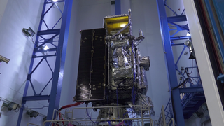
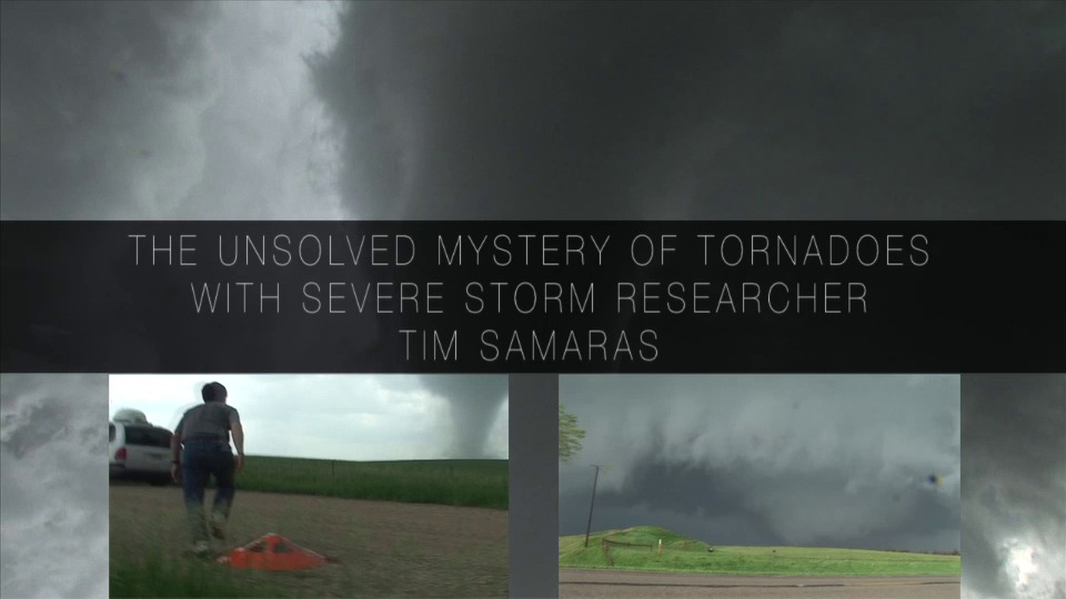
With NOAA’s revolutionary GOES-16 weather satellite in space and data flowing, the GOES-R team, a joint NOAA and NASA effort, set out to fine-tune and validate the satellite’s earth viewing instruments during what was known as the GOES-16 Field Campaign.
During the two-month long campaign, teams of instrument scientists, meteorologists, and specialized pilots used a NASA high-altitude plane, ground-based sensors, and satellites to collect and compare measurements from across the United States. With life-saving warnings and revolutionary weather data on the line, NOAA’s newest and most advanced weather satellite must be as accurate as possible.
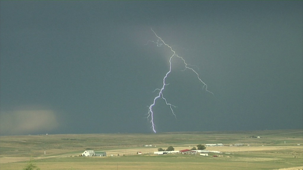
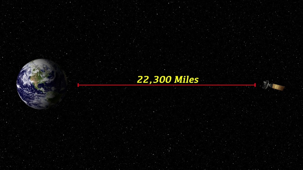
From arid deserts and areas of dense vegetation, to open oceans and storms exhibiting lightning activity, the measurements collected covered nearly everything NOAA’s GOES satellites see from their orbit 22,300 miles above the Earth. The data sets from the instruments and sensors will be analyzed and compared to validate and calibrate the GOES-16 satellite's Advanced Baseline Imager and Geostationary Lightning Mapper.
- 1280x720 mpeg-4 (22.1 MB) 29.97 fps
- SubRip caption file (for Facebook and YouTube) (0.0 KB)
- WebVTT caption file (0.0 KB)
- 1920x1080 quicktime (279.0 MB) 29.97 fps ProRes version for Video Editors
- 1280x720 mpeg-4 (4.0 MB) 29.97 fps
- 1920x1080 mpeg-4 (31.7 MB) 29.97 fps
- 1280x720 mpeg-4 (29.3 MB) 29.97 fps
- 1024x576 jpeg (112.0 KB) Still Image
- Right click movies to download them if they automatically play in your browser.
With NOAA’s revolutionary GOES-16 weather satellite in space and data flowing, the GOES-R team, a joint NOAA and NASA effort, set out to fine-tune and validate the satellite’s earth viewing instruments during what was known as the GOES-16 Field Campaign.
During the two-month long campaign, teams of instrument scientists, meteorologists, and specialized pilots used a NASA high-altitude plane, ground-based sensors, and satellites to collect and compare measurements from across the United States. With life-saving warnings and revolutionary weather data on the line, NOAA’s newest and most advanced weather satellite must be as accurate as possible.
From arid desserts and areas of dense vegetation, to open oceans and storms exhibiting lightning activity, the measurements collected covered nearly everything NOAA’s GOES satellites see from their orbit 22,300 miles above the Earth. The data sets from the instruments and sensors will be analyzed and compared to validate and calibrate the GOES-16 satellite's Advanced Baseline Imager and Geostationary Lightning Mapper.
- 1280x720 mpeg-4 (23.9 MB) 29.97 fps
- SubRip caption file (for Facebook and YouTube) (0.0 KB)
- WebVTT caption file (0.0 KB)
- 1920x1080 quicktime (259.9 MB) 29.97 fps ProRes version for Video Editors
- 1280x720 mpeg-4 (4.1 MB) 29.97 fps
- 1920x1080 mpeg-4 (30.5 MB) 29.97 fps
- 1280x720 mpeg-4 (32.6 MB) 29.97 fps
- 1024x576 jpeg (125.0 KB) Still Image
- Right click movies to download them if they automatically play in your browser.
With NOAA’s revolutionary GOES-16 weather satellite in space and data flowing, the GOES-R team, a joint NOAA and NASA effort, set out to fine-tune and validate the satellite’s earth viewing instruments during what was known as the GOES-16 Field Campaign.
During the two-month long campaign, teams of instrument scientists, meteorologists, and specialized pilots used a NASA high-altitude plane, ground-based sensors, and satellites to collect and compare measurements from across the United States. With life-saving warnings and revolutionary weather data on the line, NOAA’s newest and most advanced weather satellite must be as accurate as possible.
From arid desserts and areas of dense vegetation, to open oceans and storms exhibiting lightning activity, the measurements collected covered nearly everything NOAA’s GOES satellites see from their orbit 22,300 miles above the Earth. The data sets from the instruments and sensors will be analyzed and compared to validate and calibrate the GOES-16 satellite's Advanced Baseline Imager and Geostationary Lightning Mapper.
- 1920x1080 png (3.7 MB) Still Image
- 1024x576 jpeg (112.0 KB) Still Image
- 1920x1080 quicktime (5.1 GB) 59.94 fps
- 1920x1080 mpeg-4 (214.2 MB) 59.94 fps
- SubRip caption file (for Facebook and YouTube) (3.0 KB)
- WebVTT caption file (3.0 KB)
- 480x272 mpeg-4 (28.6 MB) 59.94 fps
- 1280x720 mpeg-4 (98.0 MB) 29.97 fps
- 320x240 mpeg-4 (34.8 MB) 29.97 fps
- 1920x1080 quicktime (1.3 GB) 59.94 fps
- 1280x720 mpeg-4 (98.0 MB) 29.97 fps *
- Right click movies to download them if they automatically play in your browser.
- * Embedded subtitles will currently only play in the Safari browser.
- 1920x1080 quicktime (6.2 GB) 59.94 fps
- 480x272 mpeg-4 (34.4 MB) 59.94 fps
- SubRip caption file (for Facebook and YouTube) (3.0 KB)
- WebVTT caption file (3.0 KB)
- 1280x720 mpeg-4 (111.4 MB) 29.97 fps
- 320x240 mpeg-4 (43.0 MB) 29.97 fps
- 1920x1080 quicktime (1.6 GB) 59.94 fps
- 1920x1080 png (3.7 MB) Still Image
- 1024x576 jpeg (112.0 KB) Still Image
- 1280x720 mpeg-4 (111.5 MB) 29.97 fps *
- Right click movies to download them if they automatically play in your browser.
- * Embedded subtitles will currently only play in the Safari browser.
Spacecraft Animations
- 1920x1080 quicktime (480.3 MB) 59.94 fps
- 480x272 mpeg-4 (2.6 MB) 59.94 fps
- 1920x1080 quicktime (239.6 MB) 59.94 fps
- 1280x720 mpeg-4 (7.9 MB) 29.97 fps
- 1920x1080 png (3.5 MB) Still Image
- 1024x576 jpeg (114.0 KB) Still Image
- Right click movies to download them if they automatically play in your browser.
- 1920x1080 quicktime (417.0 MB) 59.94 fps
- 480x272 mpeg-4 (2.6 MB) 59.94 fps
- 1920x1080 quicktime (209.4 MB) 59.94 fps
- 1280x720 mpeg-4 (6.7 MB) 29.97 fps
- 320x240 mpeg-4 (2.0 MB) 29.97 fps
- 480x272 mpeg-4 (2.3 MB) 59.94 fps
- 1920x1080 png (3.6 MB) Still Image
- 1024x576 jpeg (129.0 KB) Still Image
- Right click movies to download them if they automatically play in your browser.
- 1920x1080 quicktime (385.9 MB) 59.94 fps
- 480x272 mpeg-4 (2.2 MB) 59.94 fps
- 1280x720 mpeg-4 (6.4 MB) 29.97 fps
- 320x240 mpeg-4 (2.0 MB) 29.97 fps
- 1920x1080 quicktime (188.7 MB) 59.94 fps
- 1920x1080 png (3.5 MB) Still Image
- 1024x576 jpeg (129.0 KB) Still Image
- Right click movies to download them if they automatically play in your browser.
- 1920x1080 quicktime (383.9 MB) 59.94 fps
- 1280x720 mpeg-4 (6.3 MB) 29.97 fps
- 320x240 mpeg-4 (1.9 MB) 29.97 fps
- 1920x1080 quicktime (194.0 MB) 59.94 fps
- 1920x1080 png (3.5 MB) Still Image
- 1024x576 jpeg (106.0 KB) Still Image
- Right click movies to download them if they automatically play in your browser.
- 1920x1080 quicktime (479.8 MB) 59.94 fps
- 1280x720 mpeg-4 (8.1 MB) 29.97 fps
- 320x240 mpeg-4 (2.6 MB) 29.97 fps
- 1920x1080 quicktime (346.6 MB) 59.94 fps
- 1920x1080 png (3.7 MB) Still Image
- 1024x576 jpeg (107.0 KB) Still Image
- Right click movies to download them if they automatically play in your browser.
- 1920x1080 quicktime (9.2 GB) 29.97 fps ProRes version for Video Editors
- 480x272 mpeg-4 (129.1 MB) 29.97 fps
- 1024x580 jpeg (78.0 KB) Still Image
- 1920x1080 quicktime (9.2 GB) 29.97 fps
- 1920x1080 quicktime (4.1 GB) 29.97 fps
- 1280x720 mpeg-4 (486.6 MB) 29.97 fps
- Right click movies to download them if they automatically play in your browser.
- 1920x1080 quicktime (7.7 GB) 29.97 fps ProRes version for Video Editors
- 480x272 mpeg-4 (76.7 MB) 29.97 fps
- 1024x580 jpeg (59.0 KB) Still Image
- 1920x1080 quicktime (7.7 GB) 29.97 fps
- 1920x1080 quicktime (2.4 GB) 29.97 fps
- 1280x720 mpeg-4 (288.4 MB) 29.97 fps
- 320x240 mpeg-4 (102.7 MB) 29.97 fps
- Right click movies to download them if they automatically play in your browser.
- 1920x1080 quicktime (4.3 GB) 29.97 fps ProRes version for Video Editors
- 480x272 mpeg-4 (63.8 MB) 29.97 fps
- 1024x580 jpeg (51.0 KB) Still Image
- 1920x1080 quicktime (4.3 GB) 29.97 fps
- 1920x1080 quicktime (1.9 GB) 29.97 fps
- 1280x720 mpeg-4 (244.4 MB) 29.97 fps
- Right click movies to download them if they automatically play in your browser.
- 1280x720 quicktime (944.1 MB) 59.94 fps
- 1280x720 quicktime (2.1 GB) 59.94 fps ProRes version for Video Editors
- 1280x720 quicktime (432.1 MB) 29.97 fps (for YouTube)
- 1024x576 jpeg (130.0 KB) Still Image
- 1280x720 x-ms-wmv (80.1 MB) 29.97 fps
- Right click movies to download them if they automatically play in your browser.
- 1280x720 quicktime (2.9 GB) 59.94 fps ProRes version for Video Editors
- 640x360 quicktime (81.3 MB) 29.97 fps
- 1280x720 quicktime (240.3 MB) 29.97 fps (for YouTube)
- 640x360 mpeg-4 (34.0 MB) 29.97 fps
- 960x540 mpeg-4 (85.0 MB) 29.97 fps
- 320x240 mpeg-4 (18.0 MB) 29.97 fps
- 960x540 jpeg (142.0 KB) Still Image
- SubRip caption file (for Facebook and YouTube) (3.0 KB)
- WebVTT caption file (3.0 KB)
- 960x540 mpeg-4 (84.9 MB) 29.97 fps *
- Right click movies to download them if they automatically play in your browser.
- * Embedded subtitles will currently only play in the Safari browser.
In addition to monitoring weather on Earth, the GOES-R satellites will monitor weather in space caused by electromagnetic radiation and charged particles released from solar storms on the Sun. Many people rely on space weather data, including pilots, farmers, satellite operators, electric power workers, and astronauts.
For complete transcript, click here.
- 320x240 mpeg-4 (6.7 MB) 29.97 fps
- 1280x720 x-ms-wmv (34.7 MB) 29.97 fps
- 960x540 mpeg-4 (31.9 MB) 29.97 fps
- 1280x720 quicktime (36.3 MB) 29.97 fps (for YouTube)
- 640x360 mpeg-4 (12.8 MB) 29.97 fps
- 640x360 quicktime (28.8 MB) 29.97 fps
- 1280x720 quicktime (1.1 GB) 59.94 fps ProRes version for Video Editors
- 1235x691 png (1.1 MB) Still Image
- SubRip caption file (for Facebook and YouTube) (1.0 KB)
- WebVTT caption file (1.0 KB)
- SubRip caption file (for Facebook and YouTube) (1.0 KB)
- WebVTT caption file (1.0 KB)
- 960x540 mpeg-4 (31.9 MB) 29.97 fps *
- Right click movies to download them if they automatically play in your browser.
- * Embedded subtitles will currently only play in the Safari browser.
For complete transcript, click here.
- 1280x720 quicktime (104.6 MB) 29.97 fps (for YouTube)
- 640x360 quicktime (73.3 MB) 29.97 fps
- 320x240 mpeg-4 (17.6 MB) 29.97 fps
- 1280x720 quicktime (2.9 GB) 59.94 fps ProRes version for Video Editors
- 1280x720 x-ms-wmv (87.6 MB) 29.97 fps
- 1280x720 jpeg (125.0 KB) Still Image
- SubRip caption file (for Facebook and YouTube) (3.0 KB)
- WebVTT caption file (3.0 KB)
- Right click movies to download them if they automatically play in your browser.
The Advanced Baseline Imager (ABI) is the primary sensor on the new generation GOES satellites, GOES-R. ABI will have 16 spectral bands, which will contribute to a greater number of products and better data quality. ABI will track and monitor cloud formation, atmospheric motion, convection monitoring, land surface temperature, ocean dynamics, flow of water, fire, smoke, volcanic ash plume, aerosols and air quality, as well as vegetation health. With 5 times faster coverage rate and 4 times better spatial resolution ABI is poised to become a true success story, benefitting the public by providing critical data.
For complete transcript, click here.
- 1280x720 quicktime (450.6 MB) 30.0 fps ProRes version for Video Editors
- 1280x720 30.0 fps Frames: 1280x720_16x9_30p
- 960x540 mpeg-4 (24.0 MB) 29.97 fps
- 1280x720 quicktime (30.1 MB) 29.97 fps (for YouTube)
- 640x360 quicktime (20.6 MB) 29.97 fps
- 320x240 mpeg-4 (3.8 MB) 29.97 fps
- 640x360 mpeg-4 (9.0 MB) 29.97 fps
- 1280x720 quicktime (443.4 MB) 30.0 fps ProRes version for Video Editors
- 1280x720 jpeg (58.0 KB) Still Image
- Right click movies to download them if they automatically play in your browser.
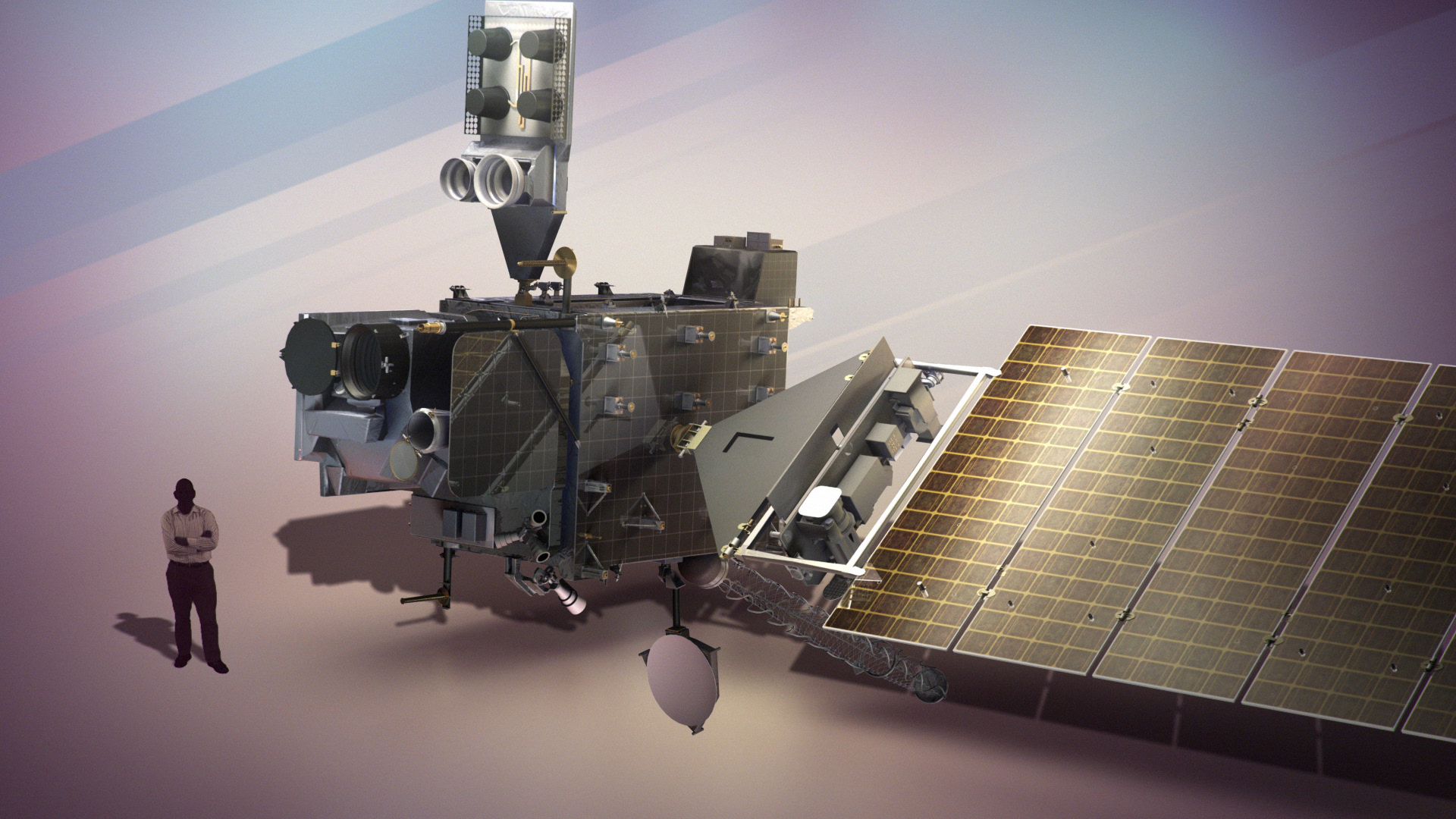
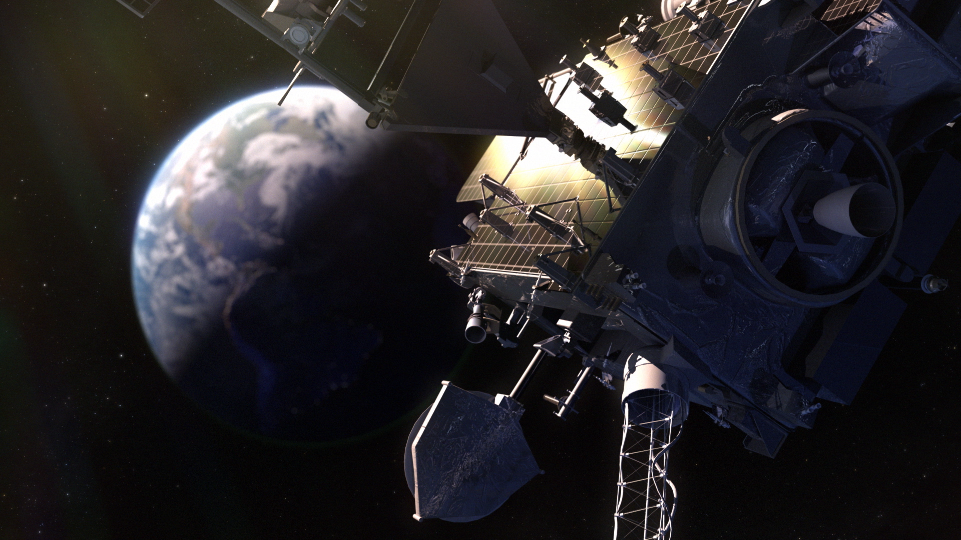
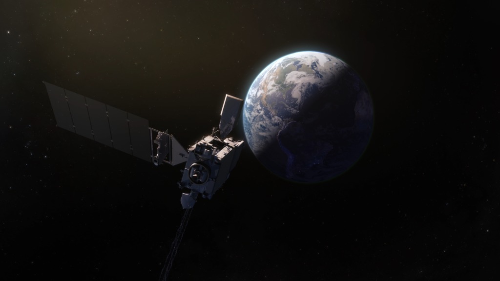
An artist concept of the GOES-R spacecraft in geostationary orbit seeing lightning from space. One of the newest features of GOES-R is the critical ability to measure and see in-cloud lightning. Thus increasing the tornado warning time.
- 640x360 quicktime (85.4 MB) 29.97 fps
- 960x540 mpeg-4 (99.8 MB) 29.97 fps
- 640x360 mpeg-4 (42.3 MB) 29.97 fps
- 320x240 mpeg-4 (21.4 MB) 29.97 fps
- 1280x720 quicktime (3.7 GB) 59.94 fps ProRes version for Video Editors
- 1280x720 x-ms-wmv (102.8 MB) 29.97 fps
- 960x540 jpeg (67.0 KB) Still Image
- SubRip caption file (for Facebook and YouTube) (4.0 KB)
- WebVTT caption file (4.0 KB)
- 960x540 mpeg-4 (99.7 MB) 29.97 fps *
- Right click movies to download them if they automatically play in your browser.
- * Embedded subtitles will currently only play in the Safari browser.
For complete transcript, click here.
- 1280x720 quicktime (3.7 GB) 59.94 fps ProRes version for Video Editors
- 1280x720 quicktime (130.4 MB) 29.97 fps (for YouTube)
- 960x540 mpeg-4 (103.5 MB) 29.97 fps
- 640x360 quicktime (100.6 MB) 29.97 fps
- 320x240 mpeg-4 (22.2 MB) 29.97 fps
- 640x360 mpeg-4 (41.5 MB) 29.97 fps
- 1280x720 x-ms-wmv (120.7 MB) 29.97 fps
- 960x540 jpeg (90.0 KB) Still Image
- SubRip caption file (for Facebook and YouTube) (4.0 KB)
- WebVTT caption file (4.0 KB)
- 960x540 mpeg-4 (103.5 MB) 29.97 fps *
- Right click movies to download them if they automatically play in your browser.
- * Embedded subtitles will currently only play in the Safari browser.
For complete transcript, click here.
- 1280x720 quicktime (1.4 GB) 59.94 fps ProRes version for Video Editors
- 1280x720 quicktime (46.3 MB) 29.97 fps (for YouTube)
- 960x540 mpeg-4 (33.8 MB) 29.97 fps
- 640x360 quicktime (29.0 MB) 29.97 fps
- 320x240 mpeg-4 (7.3 MB) 29.97 fps
- 640x360 mpeg-4 (15.1 MB) 29.97 fps
- 1280x720 x-ms-wmv (35.2 MB) 29.97 fps
- 960x540 jpeg (112.0 KB) Still Image
- Right click movies to download them if they automatically play in your browser.
- 1920x1080 quicktime (962.5 MB) 29.97 fps ProRes version for Video Editors
- 1920x1080 quicktime (374.6 MB) 29.97 fps
- 1280x720 mpeg-4 (34.6 MB) 29.97 fps
- 1024x576 jpeg (116.0 KB) Still Image
- SubRip caption file (for Facebook and YouTube) (1.0 KB)
- WebVTT caption file (1.0 KB)
- 1280x720 mpeg-4 (34.6 MB) 29.97 fps *
- Right click movies to download them if they automatically play in your browser.
- * Embedded subtitles will currently only play in the Safari browser.
- 1280x720 quicktime (100.3 MB) 29.97 fps ProRes version for Video Editors
- 1280x720 quicktime (34.8 MB) 29.97 fps
- 1280x720 mpeg-4 (6.5 MB) 29.97 fps
- 1024x576 jpeg (56.0 KB) Still Image
- SubRip caption file (for Facebook and YouTube) (0.0 KB)
- WebVTT caption file (0.0 KB)
- 1280x720 mpeg-4 (6.5 MB) 29.97 fps *
- Right click movies to download them if they automatically play in your browser.
- * Embedded subtitles will currently only play in the Safari browser.
This short video describes the top level goals of the mission.
- 1280x720 quicktime (127.4 MB) 29.97 fps ProRes version for Video Editors
- 1280x720 quicktime (40.2 MB) 29.97 fps
- 1280x720 mpeg-4 (9.0 MB) 29.97 fps
- 1024x576 jpeg (77.0 KB) Still Image
- SubRip caption file (for Facebook and YouTube) (0.0 KB)
- WebVTT caption file (0.0 KB)
- 1280x720 mpeg-4 (9.0 MB) 29.97 fps *
- Right click movies to download them if they automatically play in your browser.
- * Embedded subtitles will currently only play in the Safari browser.
- 1280x720 quicktime (110.3 MB) 29.97 fps ProRes version for Video Editors
- 1280x720 quicktime (41.6 MB) 29.97 fps
- 1280x720 mpeg-4 (7.7 MB) 29.97 fps
- 1024x576 jpeg (147.0 KB) Still Image
- SubRip caption file (for Facebook and YouTube) (0.0 KB)
- WebVTT caption file (0.0 KB)
- 1280x720 mpeg-4 (7.7 MB) 29.97 fps *
- Right click movies to download them if they automatically play in your browser.
- * Embedded subtitles will currently only play in the Safari browser.
- 1280x720 quicktime (103.4 MB) 29.97 fps ProRes version for Video Editors
- 1280x720 quicktime (44.1 MB) 29.97 fps
- 1280x720 mpeg-4 (7.0 MB) 29.97 fps
- 1024x576 jpeg (128.0 KB) Still Image
- SubRip caption file (for Facebook and YouTube) (0.0 KB)
- WebVTT caption file (0.0 KB)
- 1280x720 mpeg-4 (7.0 MB) 29.97 fps *
- Right click movies to download them if they automatically play in your browser.
- * Embedded subtitles will currently only play in the Safari browser.
Related

Credits
Chris Meaney (HTSI): Lead Animator
Silvia Stoyanova (USRA): Video Editor
Katrina Jackson (ARTS): Video Editor
Steven Goodman (NOAA): Interviewee
Lauren Gaches (NOAA): Narration
Cory Powell (NASA/GSFC): Narrator
Silvia Stoyanova (USRA): Producer
Katrina Jackson (ARTS): Producer
Tim Schmit (NOAA/NESDIS): Scientist
Swarupa Nune (Vantage): Project Support
Katrina Jackson (ARTS): Project Support
Rob Andreoli (Advocates in Manpower Management, Inc.): Videographer
Silvia Stoyanova (USRA): Writer
NASA/Goddard Space Flight Center, NOAA, Lockheed Martin
https://svs.gsfc.nasa.gov/10936
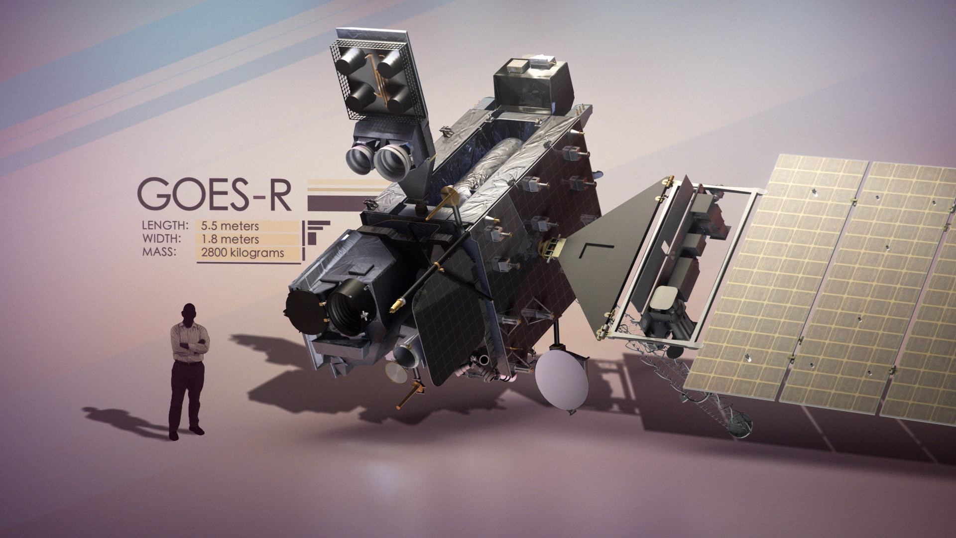
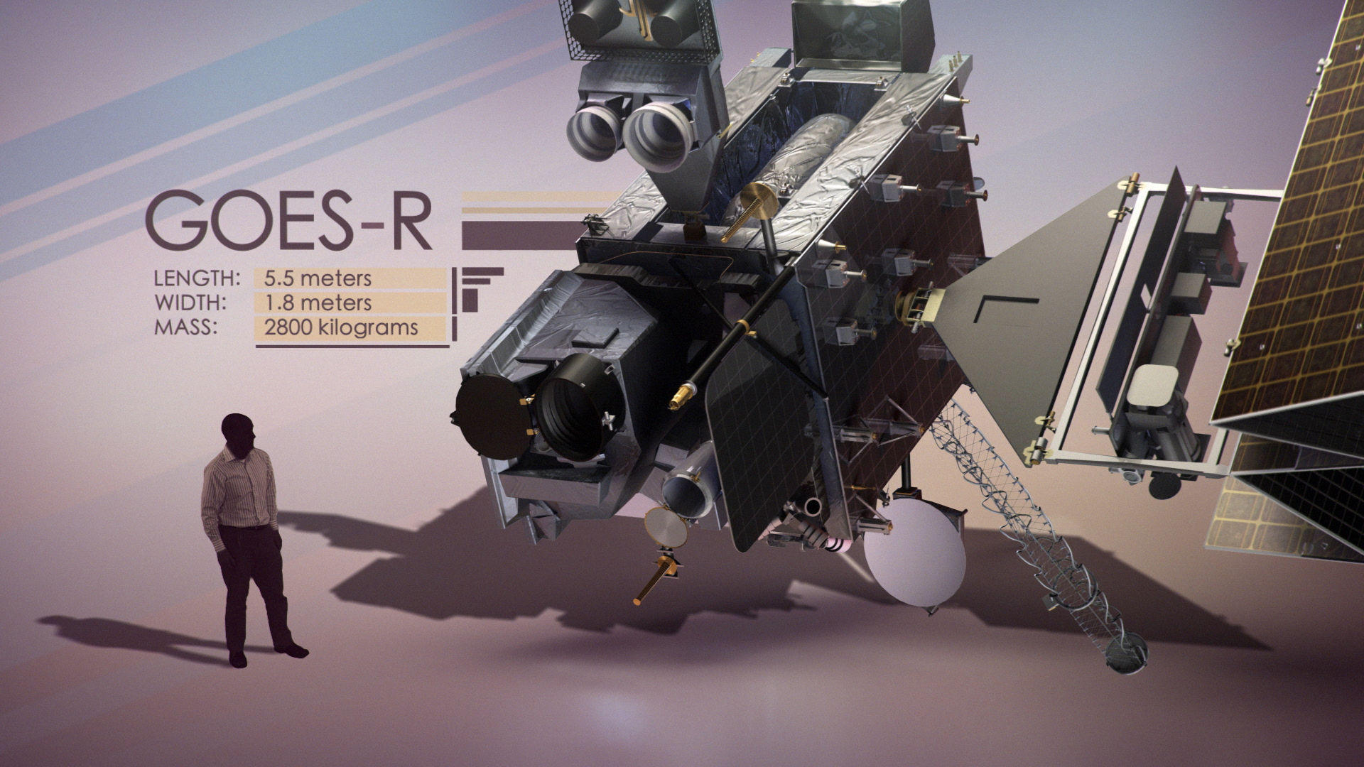
Mission:
GOES-R
This item is part of this series:
Narrated Movies
Keywords:
DLESE >> Atmospheric science
SVS >> Forecast
SVS >> HDTV
SVS >> Lightning
DLESE >> Natural hazards
SVS >> Satellite
SVS >> Solar Wind
SVS >> Weather
GCMD >> Earth Science >> Sun-earth Interactions >> Solar Activity
GCMD >> Earth Science >> Atmosphere >> Atmospheric Phenomena >> Hurricanes
GCMD >> Earth Science >> Atmosphere >> Atmospheric Phenomena >> Storms
GCMD >> Earth Science >> Atmosphere >> Atmospheric Phenomena >> Tornados
SVS >> Space Weather
SVS >> GOES
SVS >> NOAA
DLESE >> Narrated
SVS >> Earth Science >> Weather
NASA Science >> Earth
SVS >> GOES-R
SVS >> ABI
SVS >> Advanced Baseline Imager
SVS >> Thunder
GCMD keywords can be found on the Internet with the following citation: Olsen, L.M., G. Major, K. Shein, J. Scialdone, S. Ritz, T. Stevens, M. Morahan, A. Aleman, R. Vogel, S. Leicester, H. Weir, M. Meaux, S. Grebas, C.Solomon, M. Holland, T. Northcutt, R. A. Restrepo, R. Bilodeau, 2013. NASA/Global Change Master Directory (GCMD) Earth Science Keywords. Version 8.0.0.0.0
