New island forms in Tonga
There is a newer version of this story located here: https://svs.gsfc.nasa.gov/4726
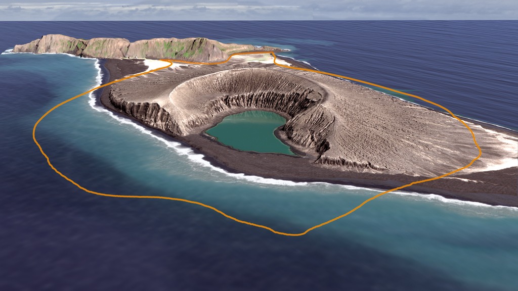
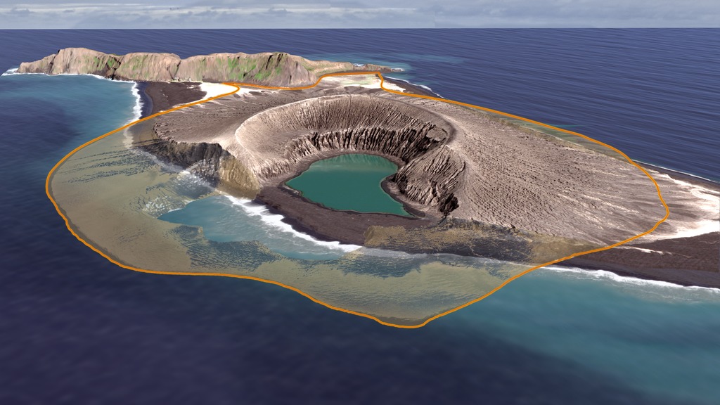
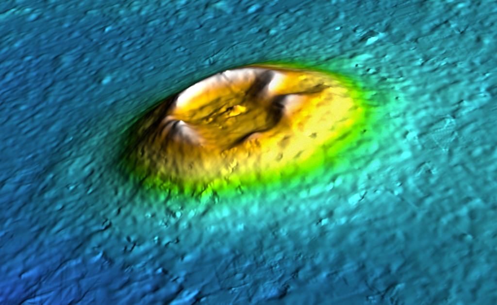
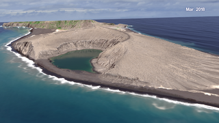
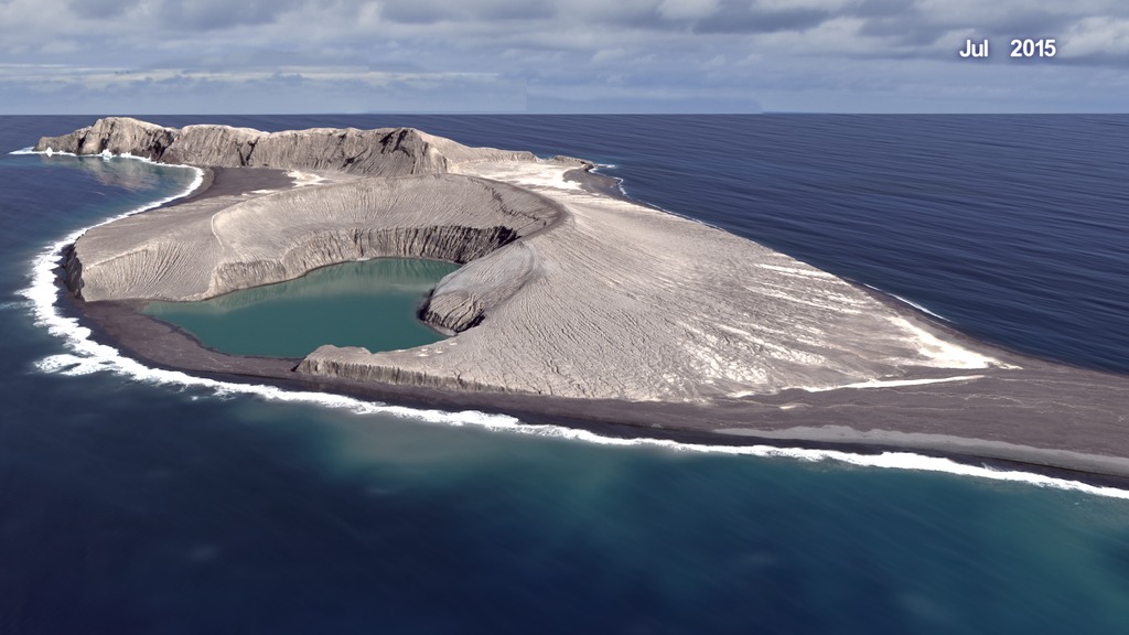
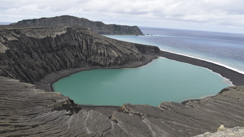
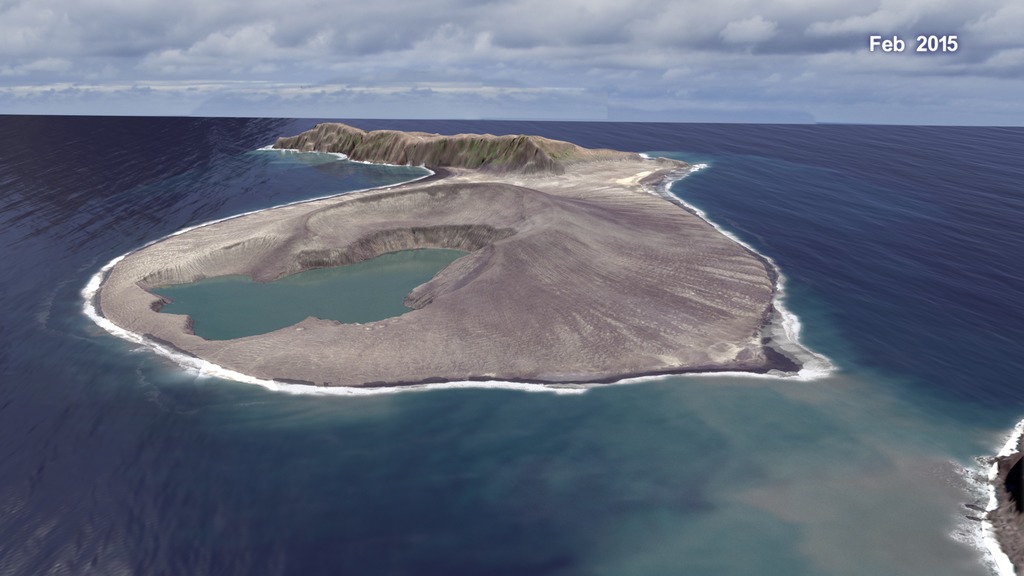
Research results from NASA-funded science team led by James B. Garvin (NASA GSFC), Daniel A. Slayback (SSAI), Vicki Ferrini (Columbia) recently submitted for publication in the AGU's Geophysical Research Letters journal suggest the island's lifetime may be extended for another 25-30 years if geochemical fortification continues to protect key regions. The HTHH island is the first surtseyan eruption-based island to have persisted as "new land" for more than 6 months since Surtsey erupted near Iceland in 1963. Studies of the landscape evolution of pristine volcanic islands of this variety previously relied on a combination of aerial photography, field mapping, and laboratory sample analysis, but this new work enables an optimized approach via advanced satellite optical and radar imaging in combination with ship-based bathymetric mapping. Results of this work can be applied to understanding numerous small volcanic landforms on Mars whose formation may have been in shallow-water environments during epochs when persistent surface water was present.
Field photography and sampling of the HTHH island "system" by French sailors who served as citizen geoscientists for the NASA project greatly enhanced the project and validated several key interpretations.
(Special thanks to NASA Earth Sciences RRNES program, French sailors Damien Grouille and Cecile Sabau of the sailing vessel Colibri, and to the Schmidt Ocean Institute R/V Falkor).
Used Elsewhere In

Newer Version
Related

Visualization Credits
Cindy Starr (Global Science and Technology, Inc.)
Scientists:
James Garvin (NASA, Chief Scientist Goddard)
Daniel A. Slayback (SSAI)
Vicki Ferrini (Lamont-Doherty Earth Observatory, Columbia University)
Producers:
Ellen T. Gray (ADNET Systems, Inc.)
LK Ward (USRA)
Samson K. Reiny (Wyle Information Systems)
Project Support:
Joycelyn Thomson Jones (NASA/GSFC)
Leann Johnson (Global Science and Technology, Inc.)
Eric Sokolowsky (Global Science and Technology, Inc.)
Technical Support:
Laurence Schuler (ADNET Systems, Inc.)
Ian Jones (ADNET Systems, Inc.)
Citizen Scientists:
Damien Grouille
Cecile Sabau
NASA's Scientific Visualization Studio
Research was largely supported by:
NASA Earth Science Division RRNES Program
(c/o Drs. Jack Kaye and Gerald Bawden)
and the Schmidt Ocean Institute
https://agupubs.onlinelibrary.wiley.com/doi/abs/10.1002/2017GL076621
Short URL to share this page:
https://svs.gsfc.nasa.gov/4602
Data Used:
Mars Reconnaissance Orbiter (MRO)/High Resolution Imaging Science Experiment (HiRISE)/HiRISE
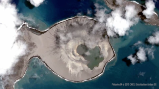
WorldView-2 © 2015 DigitalGlobe
Observed Data - DigitalGlobe - 21-Feb-2015, 27-Apr-2015, 02-Sep-2015, 17-Nov-2015, 22-Dec-2015WorldView-3 © 2015 DigitalGlobe
Observed Data - DigitalGlobe - 21-Apr-2015, 06-Jun-2015, 25-Jul-2015WorldView-2 © 2016 DigitalGlobe
Observed Data - DigitalGlobe - 02-Sep-2016WorldView-3 © 2016 DigitalGlobe
Observed Data - DigitalGlobe - 10-Apr-2016, 18-May-2016WorldView-2 © 2017 DigitalGlobe
Observed Data - DigitalGlobe - 20-May-2017, 29-Jun-2017, 19-Sep-2017WorldView-2 © 2010 DigitalGlobe
Observed Data - DigitalGlobe - 11-Sep-2010Pléiades-1A © 2015 CNES, Distribution Airbus DS
Observed Data - Distribution Airbus DS - 19-Jan-2015, 08-May-2015Keywords:
DLESE >> Geology
DLESE >> Structural geology
GCMD >> Earth Science >> Solid Earth >> Volcanoes
SVS >> Hyperwall
SVS >> Volcanic Islands
NASA Science >> Earth
GCMD keywords can be found on the Internet with the following citation: Olsen, L.M., G. Major, K. Shein, J. Scialdone, S. Ritz, T. Stevens, M. Morahan, A. Aleman, R. Vogel, S. Leicester, H. Weir, M. Meaux, S. Grebas, C.Solomon, M. Holland, T. Northcutt, R. A. Restrepo, R. Bilodeau, 2013. NASA/Global Change Master Directory (GCMD) Earth Science Keywords. Version 8.0.0.0.0
Places you might have seen this:
SVS Produced Videos/Press conference materials: TK at https://svs.gsfc.nasa.gov/12800
Youtube page for The Birth of an Island: https://youtu.be/Hds1OBxVg4s
Youtube page for A New Time-lapse of an Island Forming in Tonga: https://youtu.be/sIXyxvSEKFY
NASA Goddard Facebook post: https://www.facebook.com/NASAGoddard/videos/10156874188955898/
@NASAGoddard Tweet: https://twitter.com/NASAGoddard/status/940243741851430912
NASAEarth Facebook post: https://www.facebook.com/nasaearth/videos/10156874426085898/
@NASAEarth Twitter stream (first tweet in series): https://twitter.com/NASAEarth/status/940258617005092864
NASA Tumblr: https://nasa.tumblr.com/post/168433437659/the-birth-of-a-new-island
New Pacific Island Could Resemble Ancient Martian Volcanoes
Byline: Kenneth Chang
Publication: The New York Times
Date: Dec. 11, 2017
Audience: 39354949
"We see things that remind us of this kind of volcano at similar scales on Mars," said Dr. Garvin, the chief scientist at NASA’s Goddard Space Flight Center in Greenbelt, Md. "And literally, there are thousands of them, in multiple regions."
New Volcanic Island May Survive Much Longer Than Expected
Byline: Michael Greshko
Publication: National Geographic (US)
Date: Dec. 11, 2017
Unofficially named Hunga Tonga-Hunga Ha’apai, the new island wasn’t expected to last long. Similar volcanic islands usually erode away in a matter of months. But now, NASA scientists have announced far rosier estimates for the island’s lifespan, giving it between six and 30 years. The team unveiled their results today at the American Geophysical Union’s fall meeting in New Orleans.
Pacific 'baby island' is natural lab to study Mars
Byline: Jonathan Amos
Publication: BBC
Date: Dec. 11, 2017
"The thought was that we might be able to use recognition of these kinds of landforms to be an indication of palaeowater stories, depths and longevities on the Red Planet," said Dr Jim Garvin, chief scientist at the US space agency's (NASA) Goddard Space Flight Center.
An underwater volcano has made a mysterious new island in the South Pacific
Byline: David Anderson
Publication: Business Insider (US)
Date: Dec. 11, 2017
Audience: 20235941
Hawaii isn't the only series of islands formed from underwater volcanic eruptions. In 2014, a massive eruption formed the new island of Hunga Tonga-Hunga Ha'apai. But there's something about this island that has scientists stumped.
Pacific pop-up: island that rose from the ashes might last 30 years
Byline: Anna Livsey
Publication: The Guardian
Date: Dec. 12, 2017
A new Tongan island formed from the ash of a 2014 volcanic eruption in the South Pacific could exist for decades, according to a study released by NASA.
Newborn Pacific Island Offers NASA Insights Into Water On Mars
Byline: Suraj Radhakrishnan
Publication: International Business Times
Date: Dec. 12, 2017
The island, which was unofficially named Hunga Tonga-Hunga Ha’apai, was projected to last only a few months but latest NASA studies have shown that the island could stay for 30 years, proving an interesting area of study.
Watching this newborn island erode could tell us a lot about Mars
Byline: Carolyn Gramling
Publication: sciencenews.org
Date: Dec. 11, 2017
Audience: 160000
Since January 2015, NASA satellites have tracked the island’s growth and erosion month-to-month. Scientists are using those data to estimate its life span, said James Garvin, chief scientist of NASA’s Goddard Space Flight Center in Greenbelt, Md.