May 11, 2004 - (date of web publication)
ONGOING DROUGHT SIGNALS SEVERE FIRE SEASON IN THE ROCKIES
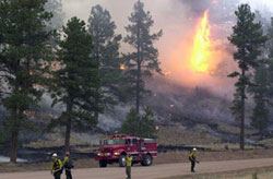
Caption for Item 1: Hayman Wildfire, Colorado, June 2002, Credit:NOAA
Wildfire management teams across the West gear up for one of the worst fire seasons to hit the Rockies and Southwestern United States. "We should be prepared for another severe fire season in the West." says Rick Ochoa, National Fire Weather Program Manager from the National Interagency Fire Center (NIFC), based in Boise, ID. The NIFC is the nation’s support center for wildlandfirefighting. They predicts another above average fire season for most of the interior West in 2004.
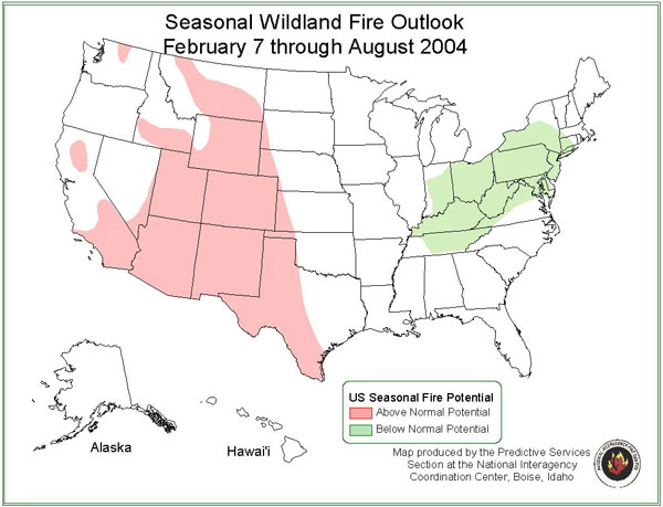
Caption for Item 2: Seasonal Wildland Fire Outlook 2004
The National Interagency Fire Center predicts an above normal potential (pink regions) for much of the Western United States this summer. This year’s fire season may be comparable to the severe fire season of 2002. Credit: NIFC
The 2002 United States wildfire season began early and grew to be the second largest in the past 50 years. Roughly 74,000 fires burned more than 7 million acres nationwide. Twenty-one firefighters lost their lives while battling U.S. fires. Arizona, Colorado and Oregon recorded their largest wildfires this century. Two particularly severe wildfires, the Rodeo-Chediski Fire in Arizona and the Hayman Fires of Colorado are examples of how drought can be used to predict fire danger.
In an effort to help fire specialists better prepare for an impending wildfire season, a fleet of satellites delivers snow pack, water level and vegetative cover data that help determine the fire potential across the country.
Less Snow Cover Suggests a Drier than Normal Rockies
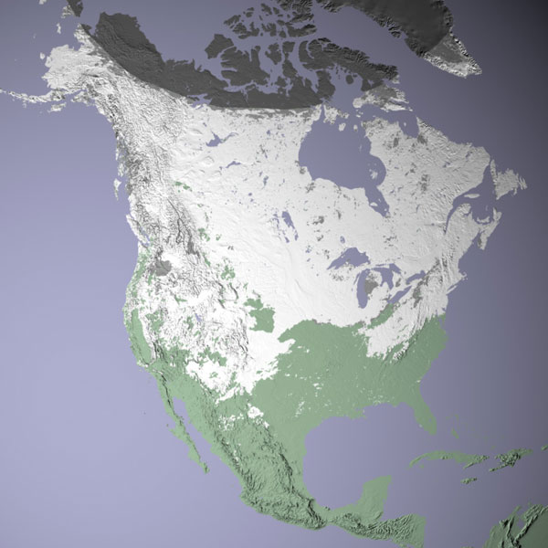
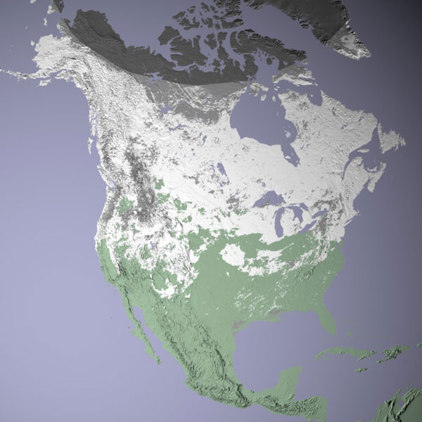
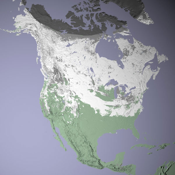
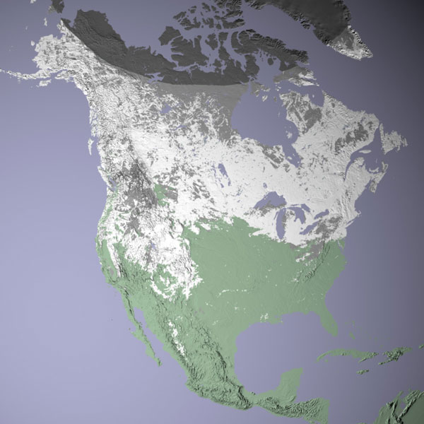
Caption for Item 3: Dwindling Snow Cover in the Rockies These images convey snow cover for North America during the same 8-day period in January for 2001 and 2004. White regions represent snow cover, green shows land areas not covered by snow, and blue is water. The gray patches represent areas where no data were collected. Terra’s Moderate Resolution Imaging Spectroradiometer (MODIS) collected the data. Credit: NASA
High resolution January 2001
January 2001
January 2002
January 2003
January 2004
Item 3 - Click on images to enlarge
High resolution January 2002
High resolution January 2003
High resolution January 2004
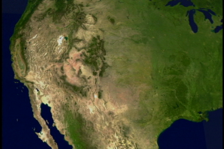
Terra’s Moderate Resolution Imaging Spectroradiometer (MODIS) collects data showing snow cover for North America. NASA launched the Terra satellite in 1999. Since then, the satellite has provided data of land, oceans, ice and air. Comparing results during the same 8-day period in January for the last four consecutive years, reveals that there can be large year-to-year changes in snow cover; these changes in turn can affect the following summer’s fire season.
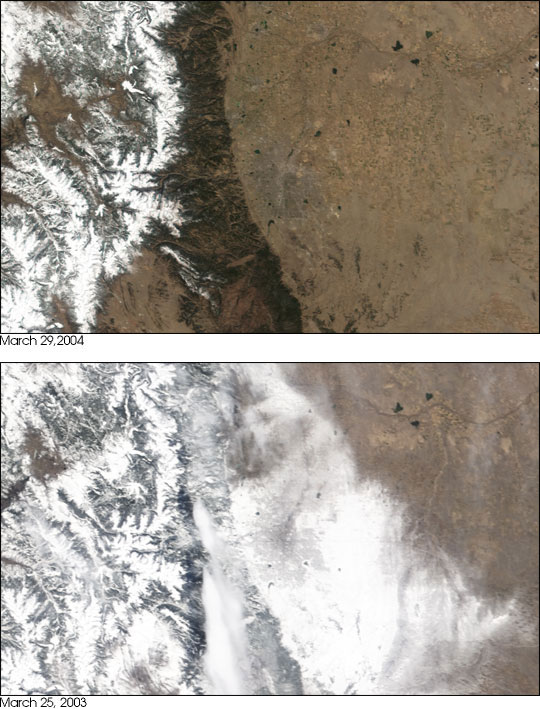
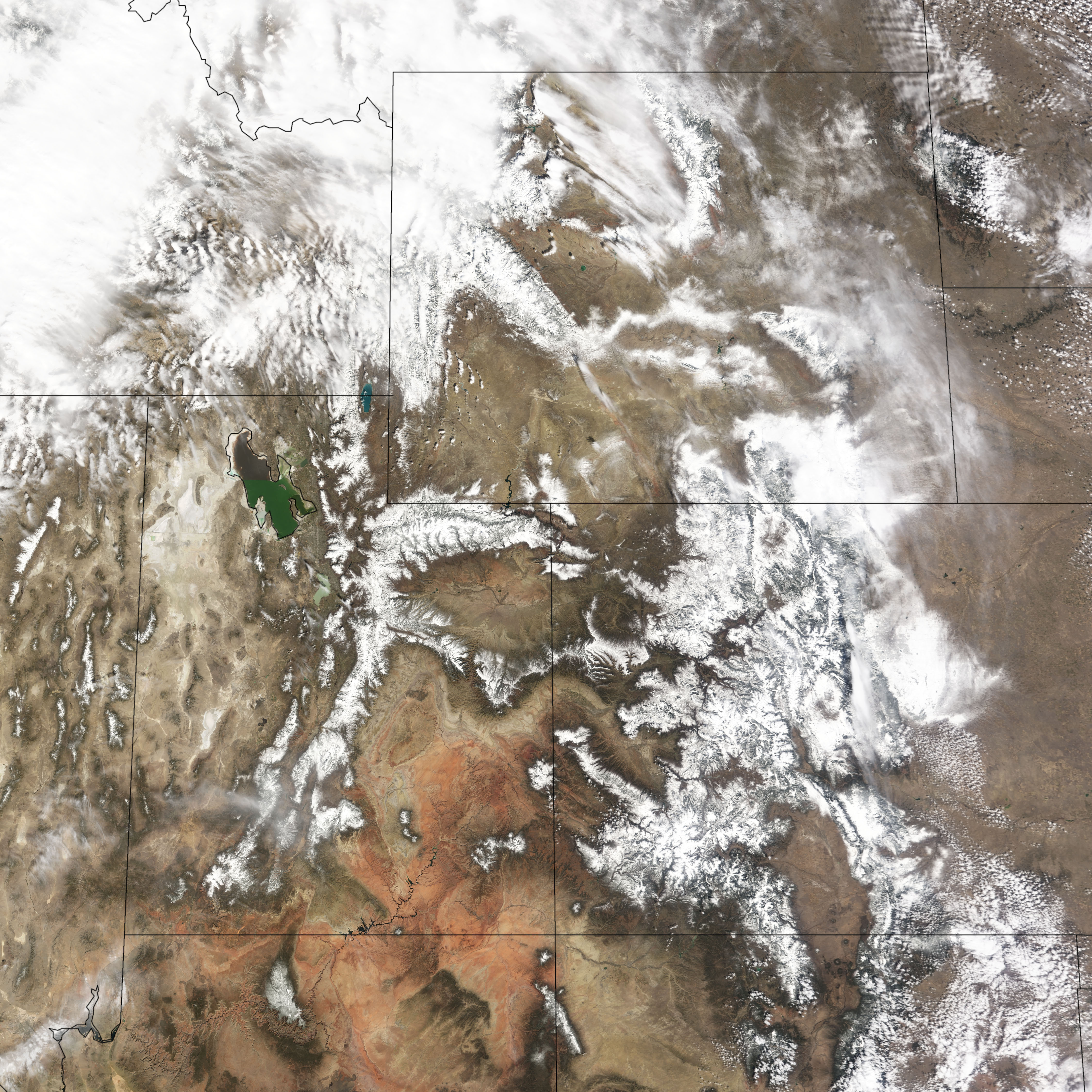
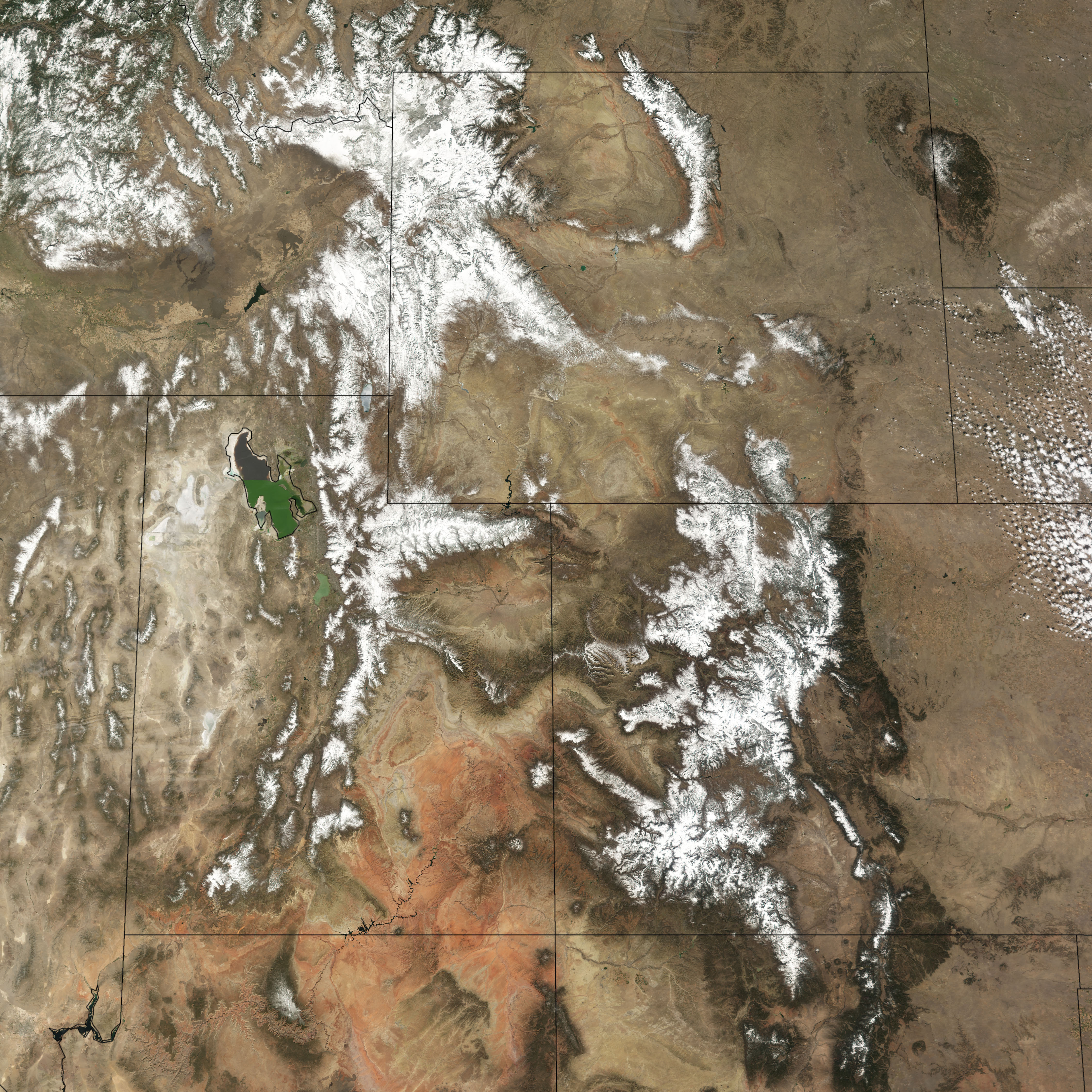
In March of 2003, a record-breaking blizzard hit Denver, temporarily alleviating Colorado’s drought and resulting fire season. The storm dropped 30 inches of snow in the valley, and as much as 87 inches in the mountains. MODIS captured images of the snow-besieged region. Although this record-setting snow alleviated the problem, it was not enough to defeat the ongoing drought.
In contrast, March of this year was one of the warmest and driest on record. "Early snow melt means the fire season can start earlier and last longer, says Rob Solhberg, NASA and University of Maryland, College Park researcher." Like most western states, Colorado gets most of its liquid assets from snow. The lack of snow reserves this year pushes that state, and likely others, toward a harrowing fire season.
Satellites Show Decreasing Water Levels
 Lake Mead 2000 high resolution
 Lake Mead 2003 high resolution
The Landsat 7 satellite, a joint project between NASA and the U.S. Geological Survey, captured images of Lake Mead in May 2000 and 2003, showing a decrease in water levels between the three years. As the Colorado Basin enters its sixth year of drought, computer models suggest water levels will go down another 15 to 20 feet this year, according to the Bureau of Reclamation. These below average water levels are indicative of the dryness out west.
Survey of Vegetative Cover Shows Dry Rockies of 2002
|
Caption for Item 5: Blizzard of 2003 Briefly Relieves Colorado From Drought These images from the Moderate Resolution Imaging Spectroradiometer (MODIS) contrast the two very different March days over Denver, Colorado. The first image shows March of 2004: one of the warmest and driest on record. The second image shows March of 2003 after a record-setting blizzard. Credit: NASA |
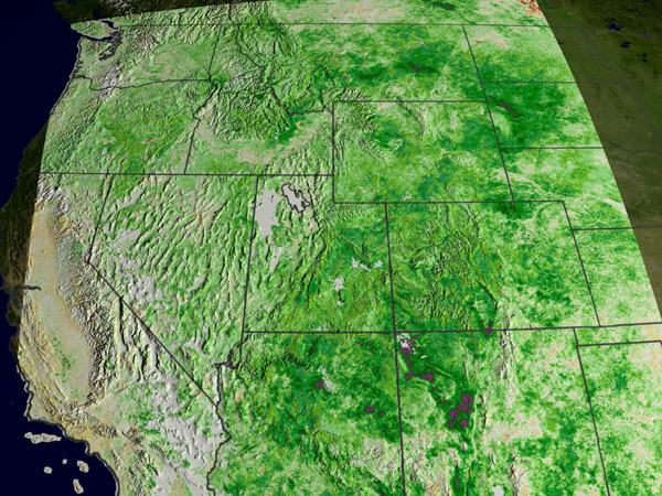
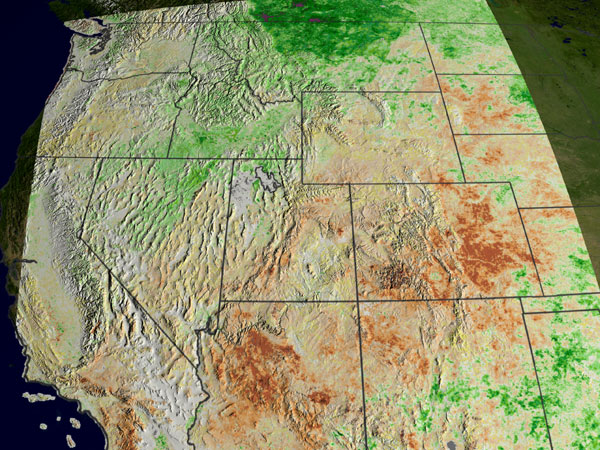
Satellite data can gauge the health of plants, which is a good indicator of drought. Though it is too early in the year to see the impact of drought in the western U.S. in 2004, satellite imagery shows changes in vegetation between 1999 and 2003. The Normalized Difference Vegetation Index (NDVI) measures how dense and green plant leaves are, which suggests overall vegetative health.
The NDVI images are also useful as a measure of drought when compared to "normal" plant health. NASA scientists calculate average NDVI values for an area to find out what is normal at a particular time of year. Images to the right show NDVI variations from what is normal in the western U.S., as measured by the vegetation instrument on Europe's SPOT satellite provided by DigitalGlobe/SPOT, under agreement with the U.S. Department of Agriculture Foreign Agricultural Service (USDA/FAS).
In 2002, drought had settled across the Midwest. Large dark brown sections of eastern Colorado show where vegetation was less lush and healthy than normal.
Satellites Work Hard on Wildfires Year Round
|
|
Item 6 - Click on each image to download high resolution TIFF. Caption for Item 6: NDVI Shows Changes Vegetation Growth in the West from 1999 to 2002 These images show the NDVI anomalies in the Western Rockies for August of 1999 and 2002. Exceptionally lush vegetation appears as a positive anomaly (green), whereas an abnormally dry region exhibits a strong negative anomaly (dark red). Abnormal dryness in 2002 impacted the record-setting fire season that year. Credit: USDA/FAS/NASA |
NASA and partnering agencies are working hard to aid the National Interagency Fire Center in predicting fire danger across the U.S. by providing snow cover, water level, and vegetation data. National fire managers rely on satellite imagery to monitor wildfire activity on a national and regional-scale to help allocate precious resources. NASA partners include Forest Service Remote Sensing Applications Center (RSAC) and the USGS EROS Data Center (EDC). Spot, Landsat and MODIS imagery were key tools in planning restoration of the Hayman and Rodeo-Chedeski. In the last three fire seasons, RSAC and EDC have mapped the post-fire conditions on 163 fires covering more than 5.4 million acres.
For more information contact:
Sarah DeWitt
Goddard Space Flight Center
Greenbelt, Md.
Phone: 301/286-0535