April 21, 2004 - (date of web publication)
2004 Space Feature Story
Special: Sibling Rivalry: A Mars/Earth Comparison
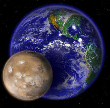
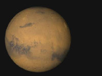
Mars and Earth
Larger version of this image available here.
Scientific understanding is often a matter of making the right comparisons. In terms of studying the Earth, one of the best comparative laboratories exists one planet over—on Mars. In many ways, the study of Mars provides Earth bound scientists with a control set as they look at the processes of climate change, geophysics, and the potential for life beyond our own planet. In January of 2004 NASA landed two extraordinary research probes on Mars as part of an international armada of exploratory vehicles sent to Earth’s dusty neighbor. Much of the technology and scientific methodology built into those missions directly relate to the sophisticated research efforts currently being used to study our own planet.
Looking at Mars, Thinking of Earth

Reporter's Package available here.
Text version of Reporter's Package available here.
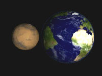
The Big Picture: Different but Not Dissimilar
Animation available here.
The similarities are striking. Each planet has roughly the same amount of land surface area. Atmospheric chemistry is relatively similar, at least as Earth is compared to the other planets in the solar system. Both planets have large, sustained polar caps and the current thinking is that they’re both largely made of water ice. The sibling planets also show a similar tilt in their rotational axises, affording each of them strong seasonal variability. The neighbors also present strong historic evidence of changes in climate. In these images, we see both planets in true color first, then draped in false color, showing relative altitudes of surface features. Blues indicates low features; reds and whites indicate high features.
Some Basic Facts about Mars• Ave. Solar Distance: 227,940,000 km (1.52 AU)
|
Some Basic Facts about Earth• Ave. Solar Distance: 149,600,000 km (1AU)
|
Olympus Mons: A Martian Peak with a View
Animation available here.
Earth is a planet constantly re-making itself. A vibrant climate, an active water cycle, and a dynamic interior reshape and redefine our home everyday, sometimes dramatically. In terms of topography, some of Earth’s biggest changes come from moving tectonic plates floating on the planet’s mantle, and volcanoes--huge outflows of heat and matter from deep inside the Earth’s crust.
But while Earth’s features eternally change, they do not persist with the same permanence as features elsewhere in the solar system. For a particularly interesting comparison, we look to Mars.
In the entire solar system, Mars boasts general features that are some of the biggest, widest, and deepest. One of its standouts is the immense Olympus Mons, a volcano of such size and scale that it’s own peak reaches above most of the Martian atmosphere. Olympus Mons could not even exist on Earth; with Earth’s stronger gravity field, the massive volcano would collapse under its own weight if it were here.
The Martian giant rises about 23 kilometers from the surrounding plains. On Earth, the closest thing resembling this volcanic giant is the Mauna Loa peak on Hawaii, which rises about 10 kilometers from its base on the floor of the Pacific Ocean. Both of these mountains are dramatically taller than the Himalayan Mt. Everest. But Mt. Everest is not a volcano; both Mauna Loa and Olympus Mons are. Their histories are described by dramatic deliveries of molten material to the surface of each planet from their respective interiors. In this sequence we see the two planets in several color schemes. We begin by flying into the Earth in true color. Then we remove the water and look at the topographic features of the planet from the ocean floor in false color, where blues indicate low points and reds are high. Next we overlay a true color, semi-transparent Olympus Mons on top of the Hawaiian Islands to provide a true-to-scale comparison of their relative sizes. Finally we pull back to see the whole of the Martian globe in true color.
Dry and Salty: Earth’s Dry Valleys in Antarctica
Animation available here. |
Animation available here. |
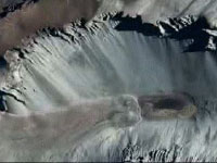
In these clips we plunge from space down to a remarkable scene in Antarctica. Specifically it’s called the Don Juan Pond, and its one of the saltiest, coldest bodies of water on Earth. In the first scene the camera slides down the valley slope and stops above the actual pond of sub-freezing water at the base. We see the crinkled folds and dug out rivulets and gullies eroded into the landscape. They serve as signs of surface erosion and are analogous to the kinds of tell-tales that Mars experts are want to study more thoroughly for signs of a wetter Martian past. This is of particular interest because it represents one possibility for the kinds of extreme conditions where life might exist elsewhere in the solar system: it’s chemically stressful due to the high concentrations of salt and minerals and exceedingly cold. If life is able to survive there, it might exist in similar places elsewhere. The second scene shows the same location, except that at the lowest point the camera traverses the upper rim of the valley. Again, we see the kinds of gullies and surface features that scientists are looking for on Mars.
To create this sequence, visualizers used data from MODIS, Landsat 7’s ETM+, and IKONOS. The images generated from that data were then each matched and color corrected to create this remarkable dive from space.
Evidence of Surface Water: Earth Deltas, Martian Deltas
Animation available here.
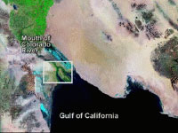
The following sequence of images compares how evidence of water appears on Earth, offering clues as to where we might look for its presence on Mars. The images shown here depict the mouth of the Colorado River in the Mexican Baja, and the Lena River Delta in Russia. Data for these scenes come from the Landsat 7 spacecraft.
The third sequence shows the so-called Distributary Fan on Mars. It’s located just northeast of Holden Crater. As seen from Martian orbit by the Mars Orbiting Camera flying on the Mars Global Surveyor spacecraft, this dramatic visualization shows us where liquid water likely flowed across the Martian surface sometime in the planet’s past. As experts gain a better understanding of the past and potential future of Martian liquid and surface water, they can refine their understanding about what forces shaped not only Mars, but planets like it—like Earth.
In these images, note that the two deltas depicted on Earth begin in color but shift to black and white. This is to emphasize several points. First, we are able to perceive significantly more data about terrestrial features using Earth observing instruments than we presently can around Mars. In other words, we know more about our own home than anywhere else. The second reason we shift the color is to highlight what analogous features might look like on Mars. As you observe the two Earth deltas in black and white and then compare the images to the Martian scene, notice how the surface features look similar—suggesting that some time long ago similar forces may have been at work on both planets.
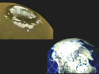
Dust in the Wind: Satellites Capture Pictures of Dust Storms on Both Planets
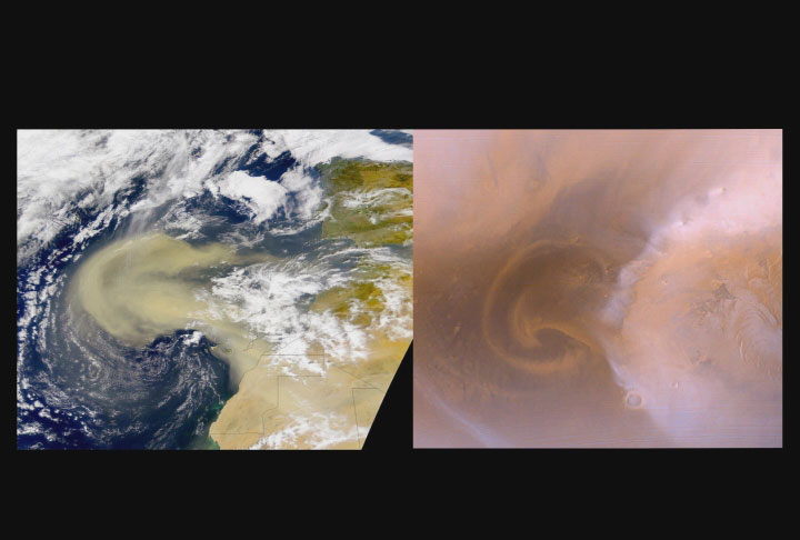
Larger version of this image available here.
Compare the following images. It should become immediately apparent that there are similar processes at work on both planets. These are pictures of dust storms appearing on Mars and Earth respectively. In the more muted image we an expanding cloud of particles—a vast dust storm blowing off the North Pole of Mars. With no apparent liquid water cycle on the surface, Martian dust storms are tremendously significant in terms of understanding planetary processes. On that planet, dust acts as a principal conveyor of heat throughout the climate system, where water principally has that job on Earth. By comparison, the similarly shaped but colorful Earth storm comes from a remarkably successful instrument called SeaWiFS. In it we see huge clouds of dust trailing off the Sahara desert, blooming like a particulate flower across the mid-Atlantic.
These comparisons are interesting because they highlight how the rules of nature function similarly even on places in the universe where their resulting effects might be significantly different.
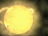
Elan Vital – The Spark of Life
Animation available here.
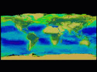
The Earth bursts with life. Everywhere we look, life not only endures, but thrives, often in surprising and comparatively innovative ways. On Earth, carbon is life’s proxy. That’s why a thorough understanding of the Earth’s carbon cycle is vital to a search for life elsewhere in the universe. The undulating colors depicted in these scenes come from NASA’s SeaWiFS instrument. They show the cycle of life as it ebbs and flows through the carbon cycle. The pulse of this carbon uptake is reflected dramatically by the oscillation of chlorophyll concentrations, depicted by this intuitive false color representation.
On Mars, scientists are looking for signs of life in the planet’s past. By ordinary Earth standards, Mars is not a hospitable place. It’s generally bathed in a lethal dose of cosmic radiation, not to mention high energy particles blown by the solar wind. It’s also cold and dry, with no readily available liquid water.
The Earth has some more protection from this kind of radiation due to its thicker atmosphere, its magnetic field, and other features. It also has a perfect oxygen/nitrogen atmosphere, a consistent general temperature, and abundant liquid water. If success if any measure of optimal conditions, Earth’s ability to foster life is ideal.
Water Warehouses—Polar Caps May Reveal Planetary Histories
Animation available here.
Both the northern and southern Martian ice caps vary in size as its seasons change. Scientists believe that the permanent northern ice cap is mostly frozen water while the southern cap is frozen water and carbon dioxide. Shown here the northern ice cap extends over a sizeable portion of the planet's pole, rippling and folding as ice and snow merge together. Its non-seasonally affected size is several times greater than its southern counterpart.
On Earth much of the planet’s fresh water is locked up in ice covering the two poles. This helps preserve a delicate balance in oceanic chemistry as well as relative temperature stasis for the planet. In the opposite corner of the screen we’re looking at Antarctica, surrounding Earth’s South Pole. And while polar ice, plus the vast ice sheet covering Greenland in the north may only represent roughly three percent of the overall water contained on Earth, it represents two thirds of all the available fresh water—water that’s vital to many of the myriad lifeforms found here.
Data now indicate that Mars’s northern polar region may contain as much water as all that’s contained on Greenland’s ice sheet—a vast tract of frozen water that’s up to three kilometers thick in some places.
Magnetic Signatures
Animation available here.
Mars does not have the same kind of magnetic field as Earth. But evidence collected by the Mars Global Surveyor (MGS) indicates that the planet may have once had a global magnetic field, generated by an internal dynamo. Evidence suggests that the planet’s magnetic field reversed direction, or flipped, several times in its early days as conditions in the mantle and core of the planet changed. But that dynamo faded, leaving only faint traces of its magnetic past locked in the Martian crust.
Scientists continue to explore these processes on Mars and how they relate to magnetic processes on Earth. And speaking of home, Earth’s magnetic field is powerful: powerful and profoundly important to everyone who lives here. It not only shows evidence of pronounced poles, but also clearly identifiable field lines—magnetic lines of force that define an intangible bubble of electromagnetic energy around the planet. The magnetic signature that defines the field around Earth acts like a protective shield from harmful solar and cosmic radiation. In many ways, the magnetic field is as much a defining characteristic of our planet as any of its other significant attributes. Not only does it protect the Earth from extraterrestrial radiation, but it also may have helped the Earth both hold on to its atmosphere and water.
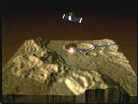
Making an Impression: Craters Suggest Clues to Past
Animation available here.
We’re looking here at a Martian impact crater called Gale. Researchers are particularly interested in this Martian landform because it appears to reveal a number of layers in the Martian crust, thus offering a rare glimpse into the structure of the planet’s upper layers. In other words, it’s a cross section of the planet’s skin, and therefore extremely valuable for researchers to ascertain many aspects about the planet’s formation and geologic history.
Layering is often associated with deposition by water here on Earth and the layers within Gale Crater on Mars may provide clues to a time in the Martian past when water-lain sediments filled up such craters.
These images were created with data partly derived from the Mars Orbiting Laser Altimeter (MOLA) instrument, flying on the Mars Global Surveyor spacecraft. The color image draped over top the topography comes from the Mars Orbiter Camera (MOC), which is also aboard the MGS spacecraft. (colors draped over the topography come from the Viking data set.) One of NASA’s rovers called Spirit recently landed in a different crater, called Gusev. Scientists consider craters valuable targets for research probes because they offer opportunities to peer beneath the superficial layer of material that covers a planet. Of particular interest about the Gusev Crater will be a determination of how and when it may have filled with water earlier in the planet’s history. These details will be probed by surprisingly sophisticated robotic experiments designed to study sedimentation and lithic mineralization found there.
But craters all over the planet are important to Mars scientists.The record of impacts found near the poles suggests that there may be a buried icescape covering much of the planet as evidenced by erosion and ejecta patterns that do not seem to behave in ways we would expect from ordinary rock-based planetary crusts. Craters on Mars are not unique. Our own moon is pockmarked with thousands of similar depressions, each the result of explosive collisions with objects inspace. The planet Mercury apparently displays similar cratering, as do the moons of the outer planets. So where are the craters we should expect to see on Earth? They’re here, but many are almost imperceptible except with sensitive remote sensing techniques and instrumentation. As a result of highly dynamic effects from water erosion and plate tectonics, craters on Earth do not tend to withstand the ravages of time as they do on other worlds. They erode, they fill in with silt, they fade into history, generally leaving only mineral traces in the surrounding area to show that a collision happened at the impact point.
However, the preserved impact craters of planet Earth are vital ground-truth for understanding the pervasive "impact process" throughout the inner solar system. Indeed, using field methods at relatively fresh craters here on Earth including those in Kazahkstan and Ghana, scientists understand how craters collect water-basedsediments here on Earth and can learn how to look for them on Mars.
Tape Measures Made of Light: Orbiting Laser Altimeters
Animation available here.
Orbiting laser altimeters fire millions of precise beams of light at the planets they survey. By measuring the two-way travel time of those laser pulses reflecting off the surface of the planets below, a precise altitude scheme can be determined and compiled. This can then be converted into a detailed topographical map.
Scientists are using this kind of technology above the Earth to make detailed measurements about changes in the Earth’s topography. The ICESat satellite is currently mapping surface features of our home planet to a degree that’s never been done before.
But the legacy preceding this Earth orbiting laboratory extends out into the solar system. A similar system flew on a satellite around Mars for several years, compiling a fantastic map of Martian terrain like no other. For years to come researchers will use that remarkable data to study Martian volcanoes, lithospheric features, and possible routes where water might have moved across the surface.
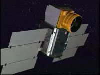
ICESat: Interplanetary Research Techniques Applied to Earth
Animation available here.
The instruments NASA deploys around other planets are often directly related to instrumentation that has a strong lineage of Earth experience. Take the single instrument flying on the space agency’s ICESat vehicle. Called GLAS (the Geoscience Laser Altimeter System), it sends out two different colored pulses of laser light 40 times a second as it circles the globe and then collects the reflected light from the surface in a custom built, one-meter telescope.
This is very similar to the instrument that flew on the Mars Global Surveyor spacecraft. Called MOLA (Mars Orbiting Laser Altimeter), this instrument also collected data by bouncing a laser off the surface of the planet it orbited.
ICESat’s legacy is directly related to work done around Mars. With a charge to collect information about Earth’s cloud cover, oceans, vegetation, and changing topography, the satellite’s principal goal is to measure changes in the permanent layer of ice that covers wide areas around the planet’s poles.
New Maps: Surface and Sky
Animation available here.
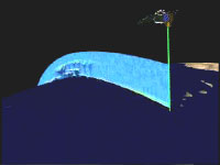
ICESat’s orbit was designed to maximize coverage over the Earth’s principal ice sheets, specifically found near the poles. In Antarctica, this data has produced a new three dimensional elevation model in more detail than ever before. In addition, ICESat is enabling researchers to study the structure and composition of clouds in exciting new ways. As the laser passes through the atmosphere, reflected light back to the satellite can provide a wealth of information.
In terms of surface measurements these findings will help scientists determine precisely when and how quantities of ice and snow are rising or falling the middle of ice sheets. Moreover, this information will be able to be compared to data from surrounding years, thus enabling better understandings about human induced and naturally occurring climate change.
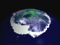
Criss-crossing the Earth
Animation available here.
Each pulse of laser light fired from the GLAS instrument can only detect surface features about the point on the globe that it illuminates. That’s why any meaningful information it delivers is an amalgam of millions of pulses, built up over time. As the ICESat satellite traverses the Earth, the record of data points increases. Researchers can then map the surface incrementally: as the data record gets denser, the finer the level of detail in some features becomes.
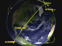
The Earth Observing Fleet
Animation available here.
While NASA prepares to deploy a new family of probes around the fourth planet, it’s exciting to consider that it already maintains a powerful and diverse fleet around the third planet. NASA’s Earth Observing fleet of vehicles constitutes a major milestone in the history of Earth science, facilitating kinds of wide scale and synergistic research endeavors that until the last decade have been impossible to even consider.
Many of the techniques being employed around Earth are a direct offshoot of technological and scientific techniques developed on missions to other worlds. As the Red planet looms large in our view screens, we reflect that NASA’s continued commitment to primary research about our home remains a top priority not only to the agency, but to the nation, and the world as a whole.
Special Thanks to:
Dr. Jim Garvin, Chief Scientist, NASA Mars Exploration Program
The Official Reproduction Guidelines for use of NASA images and emblems
This multimedia project is the work of a dedicated team of researchers, animators, and media specialists. A detailed companion video to this web site is available from NASA-TV. Below are a list of agencies, departments, and researchers who provided expertise and data for this production:
NASA Goddard Space Flight Center Television Production
NASA-TV/GSFC Visualizations by GSFC Scientific Visualization Studio
Animations by GSFC Conceptual Image Lab
Content Preparation & Project Production: Michael Starobin and Mike McClare
GSFC Public Affairs Contact: Wade Sisler
Web Content Manager: Lynn Jenner
For further information about NASA’s ongoing missions to Mars, other interplanetary explorations, the Earth observing fleet, and other exciting research conducted by the space agency and its partners, check out the following web sites:
NASA NASA’s Mars Exploration Rover Mission The Earth Science Enterprise NASA’s Earth Observing System The Earth Observatory The Remote Sensing Tutorial The Landsat Gateway