Earth
ID: 5148
Weather models begin their forecasts by integrating observations from ground stations, aircraft, balloons, and a growing constellation of Earth observing satellites to estimate the most realistic atmospheric state. The Goddard Earth Observing System Forward Processing (GEOS-FP) system is a research model maintained by NASA’s Global Modeling and Assimilation Office to demonstrate innovative new ways to use satellite data to improve predictions of weather, air quality, and greenhouse gases and to help NASA collect new observations of our home planet.
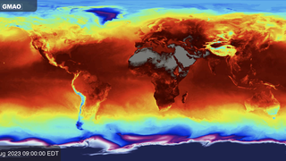
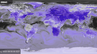
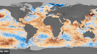
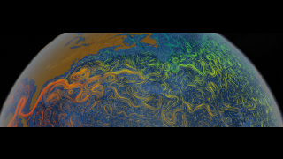
Near surface wind speed is calculated by sampling model fields at 10 meters (about 30 feet) above Earth’s surface. Wind speed is typically largest over ocean because surfaces are smooth and result in less friction than over land. Organized patterns reflect weather fronts and storm systems around the world. Near surface winds help scientists track the movement and severity of storms and air pollution episodes. Increasingly, these kinds of products help wind energy managers plan resources to help meet the world’s demand for energy while reducing the greenhouse gas emissions that cause climate change.
GEOS-FP Near Surface Wind Speed
Near surface wind speed is calculated by sampling model fields at 10 meters (about 30 feet) above Earth’s surface. Wind speed is typically largest over ocean because surfaces are smooth and result in less friction than over land. Organized patterns reflect weather fronts and storm systems around the world. Near surface winds help scientists track the movement and severity of storms and air pollution episodes. Increasingly, these kinds of products help wind energy managers plan resources to help meet the world’s demand for energy while reducing the greenhouse gas emissions that cause climate change.
Related
Visualization Credits
Joseph V. Ardizzone (NASA/GSFC): Lead Visualizer
Please give credit for this item to:
NASA’s Global Modeling and Assimilation Office
NASA’s Global Modeling and Assimilation Office
Short URL to share this page:
https://svs.gsfc.nasa.gov/5148
Data Used:
Note: While we identify the data sets used in these visualizations, we do not store any further details nor the data sets themselves on our site.
Keywords:
SVS >> Hyperwall
SVS >> GMAO
NASA Science >> Earth
NASA Earth Science Focus Areas >> Weather and Atmospheric Dynamics
SVS >> Earth Information Center
https://svs.gsfc.nasa.gov/5148
Data Used:
GEOS-FP
Model - NASA GMAO
Documentation: Lucchesi, R., 2018: File Specification for GEOS FP. GMAO Office Note No. 4 (Version 1.2), 61 pp, available from [https://gmao.gsfc.nasa.gov/pubs/docs/Lucchesi1203.pdf](https://gmao.gsfc.nasa.gov/pubs/docs/Lucchesi1203.pdf)
Keywords:
SVS >> Hyperwall
SVS >> GMAO
NASA Science >> Earth
NASA Earth Science Focus Areas >> Weather and Atmospheric Dynamics
SVS >> Earth Information Center